Measure. Analyse. Present.
|
Visivi is an unrivalled collaboration tool for linear asset constructors, regulators and contractors, providing immediate 'eyes on site' to help facilitate tasks which historically needed a site-visit.
Developed by RSK Orbital (part of the RSK Group), we can help you to Measure your assets using the latest image and data collection tools, assist in the Analysis of any problems, findings and trends and then use Visivi to Present and share with colleagues and other stakeholders. Simple to use, bespoke and cloud-based. Visivi is a Virtual Site Visit allowing you to save time, reduce cost and eliminate risk |
| Photography
|
|
|
Visivi’s multi-faceted applications constantly deliver incredible benefits to many industries around the world. Currently used by numerous bluechip clients, including Network Rail (Routeview), National Grid, HS2, Shell, BP, Scottish Power, Ineco Harramain, TOTAL, Synerail and many more. Visivi has been crucial in communicating issues to routers, environmental managers, engineers, bidders, regulators and even to the public during outreach programs. With Visivi used by large scale linear clients in North America, Northern Europe, the Middle East and the former Soviet Union, it truly does have global spread. All have all benefited from using this powerful, accessible and extremely useful tool that brings the outside world to your fingertips.
|
Benefits of Visivi from those who use it daily
|
Users easily shared their |
|
Explore Linear Assets. |
The Power of the Image. |
|
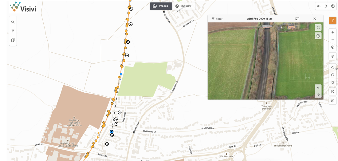
Visivi combines overlapping, oblique, high-resolution (80 megapixel), forward and backward facing aerial photography with online satellite imagery (the detail of which ends as Visivi’s starts) and client specific vector mapping. Photography detail provides precise visual access for large, disparately located teams, simply, clearly and quickly. Visivi’s virtual site visits deliver significant time and cost savings by reducing field visits and internal meetings to an absolute minimum.
Now only site trips that are truly necessary need to be taken. |
Visivi’s incredible strengths are contained within its high-resolution, overlapping images and cloud-based delivery. This enables multiple users to simultaneously access and view the same image, despite being in widely different geographic locations. The result is a ‘Virtual Site Visit’ that facilitates accurate, fast and collaborative decision-making with zero travelling and zero environmental impact.
Communicating complicated information to third parties, regulators and contractors is now quick and easy with imagery and mapping that can be used in external digital documents, letters and reports. |

By using Visivi, engineers can now plan survey areas from their desks. Collected data is uploaded directly from the field, quickly and smoothly, eliminating the need for a physical site visit.
Every Visivi image is geo-referenced, meaning CAD and GIS data can be overlayed onto the imagery, allowing the capability to measure distances, find coordinates, calculate feature proximity and population densities along the route. Visivi’s personalisation also allows the linking of external files such as ground-based photography, documents or video.
Every Visivi image is geo-referenced, meaning CAD and GIS data can be overlayed onto the imagery, allowing the capability to measure distances, find coordinates, calculate feature proximity and population densities along the route. Visivi’s personalisation also allows the linking of external files such as ground-based photography, documents or video.
|
Pre-refurbishment asset condition assessment
|
New Build Application route selection
|
The safety and efficiency benefits fed back by some of our thousands of users has proven Visivi to be a valuable tool in helping us reduce the safety risks of site visits and lineside access for both employees and contractors as well as helping us to increase efficiency through the easy to access availability of both current & historic asset and lineside condition information at the desktop.
Years of Experience.